Data entry
Update 26 October 2025.
The current position at 20 October 2025 for tetrad recording in the 2020–2025 period is as the map below. The dots indicate the number of records gathered to that date.
The map is also very useful to see ‘blank’ areas still awaiting records, and which tetrads have few records.
More records are continually added to the database from multiple sources, and this map will be updated at intervals.
NB: to help distinguish the symbols of coverage where colours are similar, note that the dot-sizes are scaled. Click/select the map to open it in a new window.
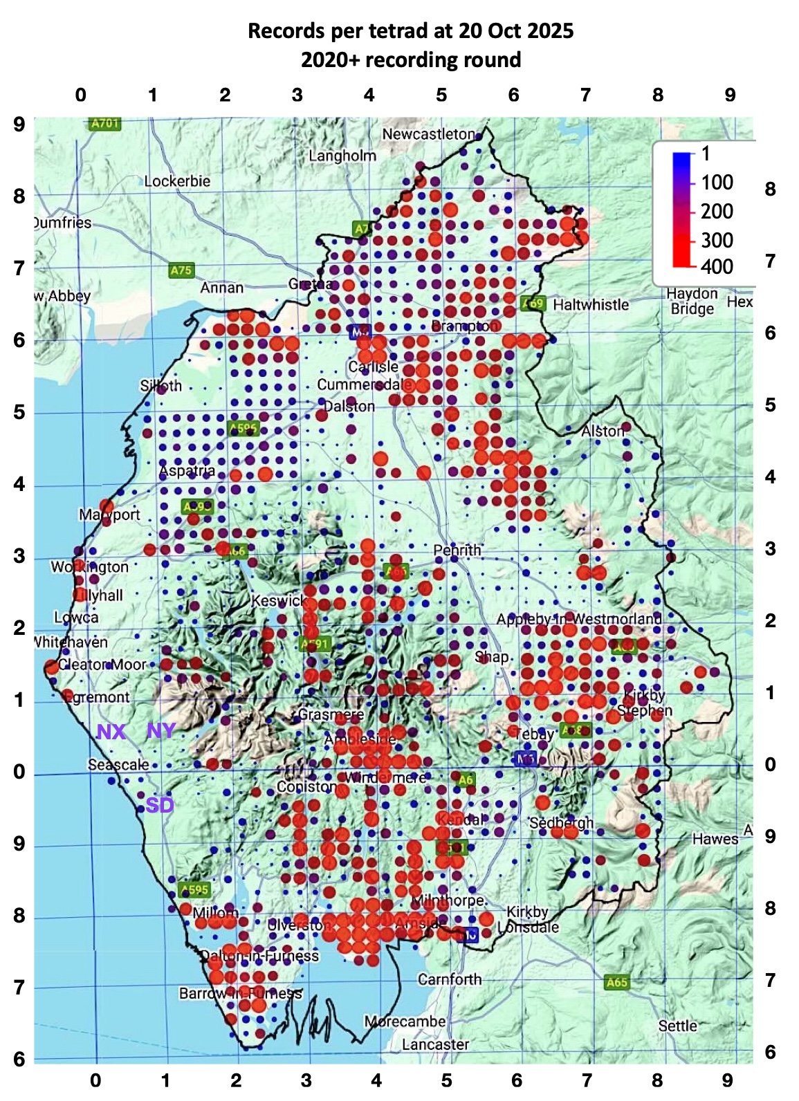
Records 2020–24 were collected as follows (data from BSBI distribution database):
2020
23,203 (in 728 monads)
2021
25,024 (in 796 monads)
2022
35,125 (in 1096 monads)
2023
30,191 (in 1245 monads)
2024
37,518 (in 1036 monads)
Total 2020~2024
134,667 (in 3026 monads, 41% of the total ~7420 monads)
Accounts and maps archived below are from the lead-up to the end of the 2000–2019 cycle.
~~~~~~~~~~ Archive ~~~~~~~~~~~
The tetrad map below shows the position at the end of the BSBI’s 2000–2019 round of recording. The dots show number of species recorded within that period.
After prodigious efforts by our team over the period, there remained only 28 tetrads without a ‘50+ dot’, and these were all marginal (i.e. coastal, or across county boundaries, and hence with less than a 4 sq. km area, often much less, within vice-counties 69 and 70). This is a position that might have seemed impossible for us to achieve, looking at the state of recording just a couple of years ago! (See the maps below.) Many thanks to everyone who contributed records from 2019 and from previous years. (In 2019 Phill Brown – as well as inputting very many thousands of our records (over 100,000 so far?) through MapMate, a huge contribution of time and effort – himself gathered a quarter of these! We are deeply indebted to him! – JR)
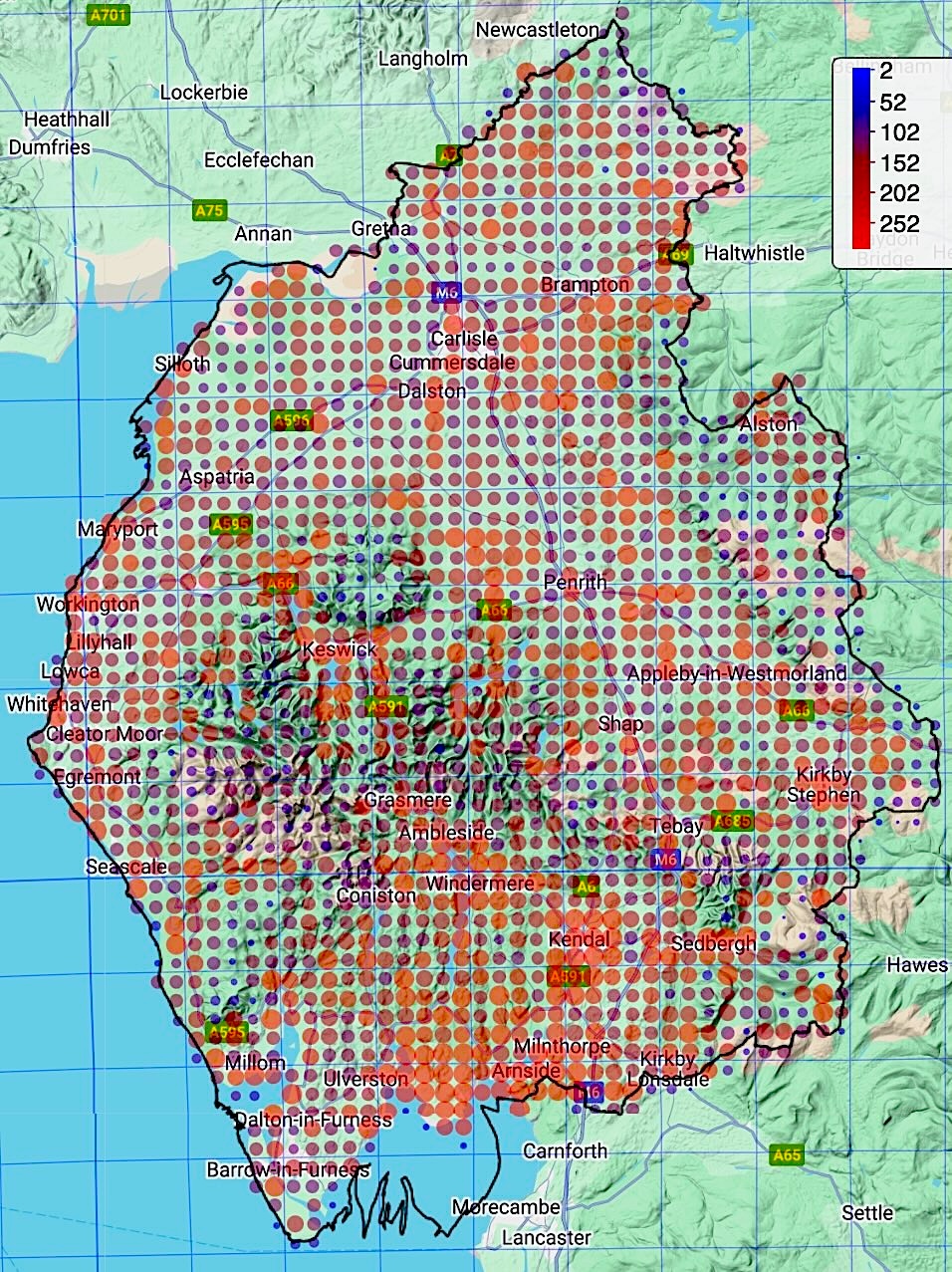
The diversity of vascular plant species in the county decreases somewhat from south to north, but at any one spot is also obviously highly dependent upon altitude, soil-type, land-use, presence of river-courses, etc. A typical lowland tetrad in this part of the planet with a reasonable range of habitats should reveal at least 250–300 species after a thorough survey, with visits through the season. In southern Cumbria, this may rise to over 400.
[⇠⇠ Back to Recording Cumbria’s Flora…]
Hi. I’m from VC55(Leics and Rutland) and will be living in Workington until the middle of May. I’ve spoken to Mike, and he suggests I join this group as a temporary member, and he will be sorting some squares for me to record whilst I’m up here. I look forward to hopefully meeting up with some of you in the near future.
All the best,
Richard Mabbutt VC55 botanical recorder.
Hi Richard – I think you’ve had some good responses to this on the FB page, which I hope have given you some ideas.
BTW – I had earlier said I’d have a look at that polypody specimen of yours for an ID if you’re interested. Cheers, Jeremy.